
Chesapeake Bay TMDL Basics
Despite nearly 30 years of clean-up efforts from all levels of government, conservation groups and others, the Chesapeake Bay watershed remains a challenged ecosystem. The tidal waters of the Bay continue to be enriched with the nutrients nitrogen and phosphorus, and sediment. This excess of nutrients and sediments leads to problems such as annual dead zones, loss of habitat for aquatic species in the Bay and tidal waters, as well as localized water quality concerns in many upstream rivers.

As a result, in accordance with the federal Clean Water Act, the U.S. Environmental Protection Agency is directing the Chesapeake Bay states and the District of Columbia to develop and implement a “pollution diet” for the Bay and its tidal waters known as a Total Daily Maximum Load (TMDL). In short, the TMDL establishes how much nitrogen, phosphorus and sediment can flow into the waters of the Bay while maintaining a water quality standard that will allow for improved water quality and aquatic habitats.
Federal lands and facilities represent approximately 12.3% of all land in Virginia’s Chesapeake Bay watershed. They include more than 200 facilities, owned or managed by over a dozen federal agencies including LaRC.
The Commonwealth is utilizing MS4 permits to ensure that BMP implementation on existing developed regulated federal lands achieves nutrient and sediment reductions equivalent to Level 2 scoping run reductions by 2025, or a more stringent level agreed to by the Commonwealth of Virginia, the EPA and the federal agencies pursuant to EO 13508, EISA §438 and EO 13514. Level 2 implementation equates to an average reduction of 9% of nitrogen loads, 16% of phosphorus loads and 20% of sediment loads from impervious regulated acres, and 6% of nitrogen loads, 7.25% of phosphorus loads and 8.75% sediment loads beyond 2009 progress loads for pervious regulated acreage.
Turning the Plan into Action
Federal MS4 operators, like other MS4s, will be given three full permit cycles (15 years) to implement the necessary reductions to meet the L2 implementation levels. Baseline efforts will be based upon 2009 progress loads. The baseline efforts will be continued with an expectation of an additional 5% reduction of loads for existing developed lands to be met by the end of the first permit cycle. As a part of reapplication for the second cycle of permit coverage, the MS4 operator will provide a schedule of implementation of the means and methods to implement sufficient reductions to reach 35% of the L2 reductions. As a part of reapplication for the third cycle of permit coverage, the MS4 operator will provide a schedule of implementation of the means and methods to implement sufficient reductions to reach the remaining L2 reductions by the end of the third permit cycle.
The Chesapeake Bay TMDL requires NASA LaRC to develop a Chesapeake Bay TMDL Action Plan (“CB Action Plan”) that is submitted to the Virginia Department of Environmental Quality (DEQ). In the CB Action Plan, LaRC provides an overview of the management practices and retrofit programs that will be implemented to achieve the reduction of sediment and nutrients, or pollutants of concern (POC).
2009 Land Use Statistics for loads
The first step in determining source loads reductions was to perform an in depth analysis of LaRC’s land use as of June 30, 2009. A breakdown of LaRC’s 764 acreage is summarized in the table below:

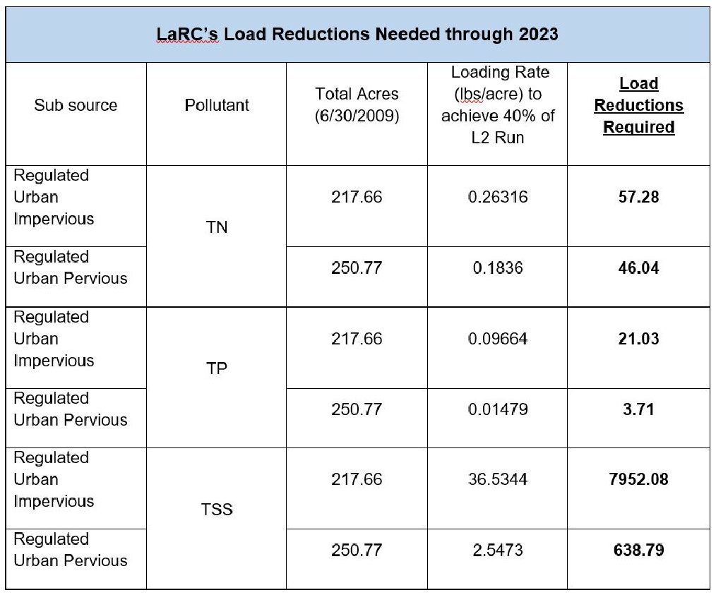
What does our load allocations look like?
The POC loads and required reductions have been calculated using tools described in the TMDL Guidance document. The following table showcases LaRC’s existing source loads:

Tracking LaRC’s Load Reduction Progress
First Permit Cycle (2009 – 2018): Reduction Achievements
During LaRC’s first permit cycle , several management practices and retrofit programs were utilized and implemented to achieve at least 5.0% reductions for existing sources. In summary, a total of 10.7 acres of impervious structures were demolished and converted to grass condition; while these areas are mowed periodically, they do not receive nutrient applications, allowing them to be classified as a grass condition. Street sweeping was utilized during all years of permit cycle one; all roads and parking surfaces on Center were swept on a quarterly basis. Additionally, 3.62 acres were converted to a forested condition (0.32 acres converted from impervious to forest; 3.3 acres converted from pervious to forest). Stormwater retrofits were also completed via the installation of tree-box filters capable of filtering stormwater pollutants around the Center.
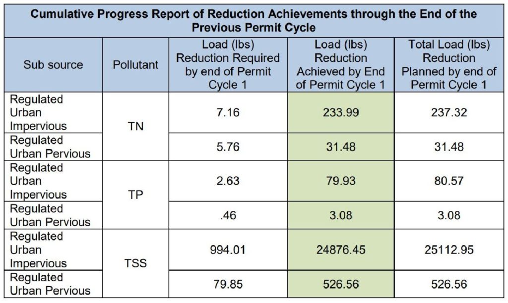 Note: differences in reduction achieved versus reduction planned under ‘Regulated Urban Impervious’ were due to a land use change (impervious to grass) that was moved from FY18 to FY19. Land use change and reduction was achieved under the second permit cycle (2018-2023).
Second Permit Cycle (2018 – 2023)
LaRC’s CB Action Plan- Phase II described the management practices and retrofit programs implemented between July 1, 2018 and June 30, 2023 to achieve reduction goals. The table below shows the reductions that were required during the cycle:
Third Permit Cycle (2023 – 2028)
LaRC’s current CB Action Plan- Phase III describes the management practices and retrofit programs that are to be implemented between November 1, 2023 and October 31, 2028 to achieve reduction goals. It demonstrates LaRC’s ability to ensure compliance with the Special Condition, and includes the means/methods to meet or exceed an additional 60% of Level 2 (L2) scoping run reductions for existing development by the end of this permit cycle (2028). In combination with the 40% reduction of L2 that has already been achieved, a total reduction no later than October 31, 2028, of 100% of L2 will be achieved. Level 2 implementation equates to an average reduction of 9.0% of nitrogen loads, 16% of phosphorus loads, and 20% of sediment loads from impervious regulated acres and 6.0% of nitrogen loads, 7.25% of phosphorus loads, and 8.75% of sediment loads from pervious regulated acres beyond 2009 progress loads and beyond urban nutrient management reductions for pervious regulated acreage.
You can learn more by checking out:
Here are some projects and best practices we’ve implemented:
- Land use conversion. LaRC has been demolishing acres of unused impervious surfaces and transitioning them back to green space. Thus, we reduce our impervious surfaces and earn a pollutant load reduction credit.
- A riparian buffer area was planted on Center. Approximately, 600 trees were planted near the NW Branch of the Back River. This area is being returned to a natural buffer area.
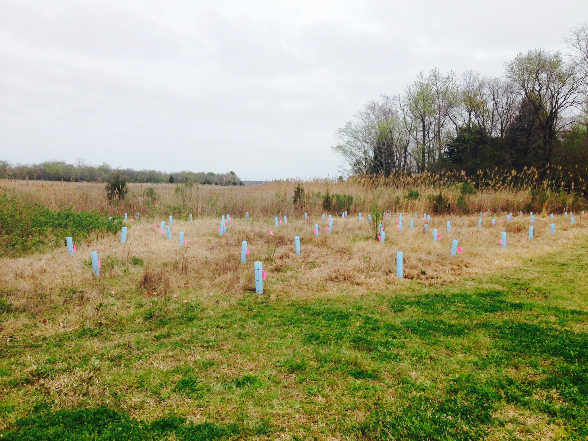
Picture of a riparian buffer after planting.
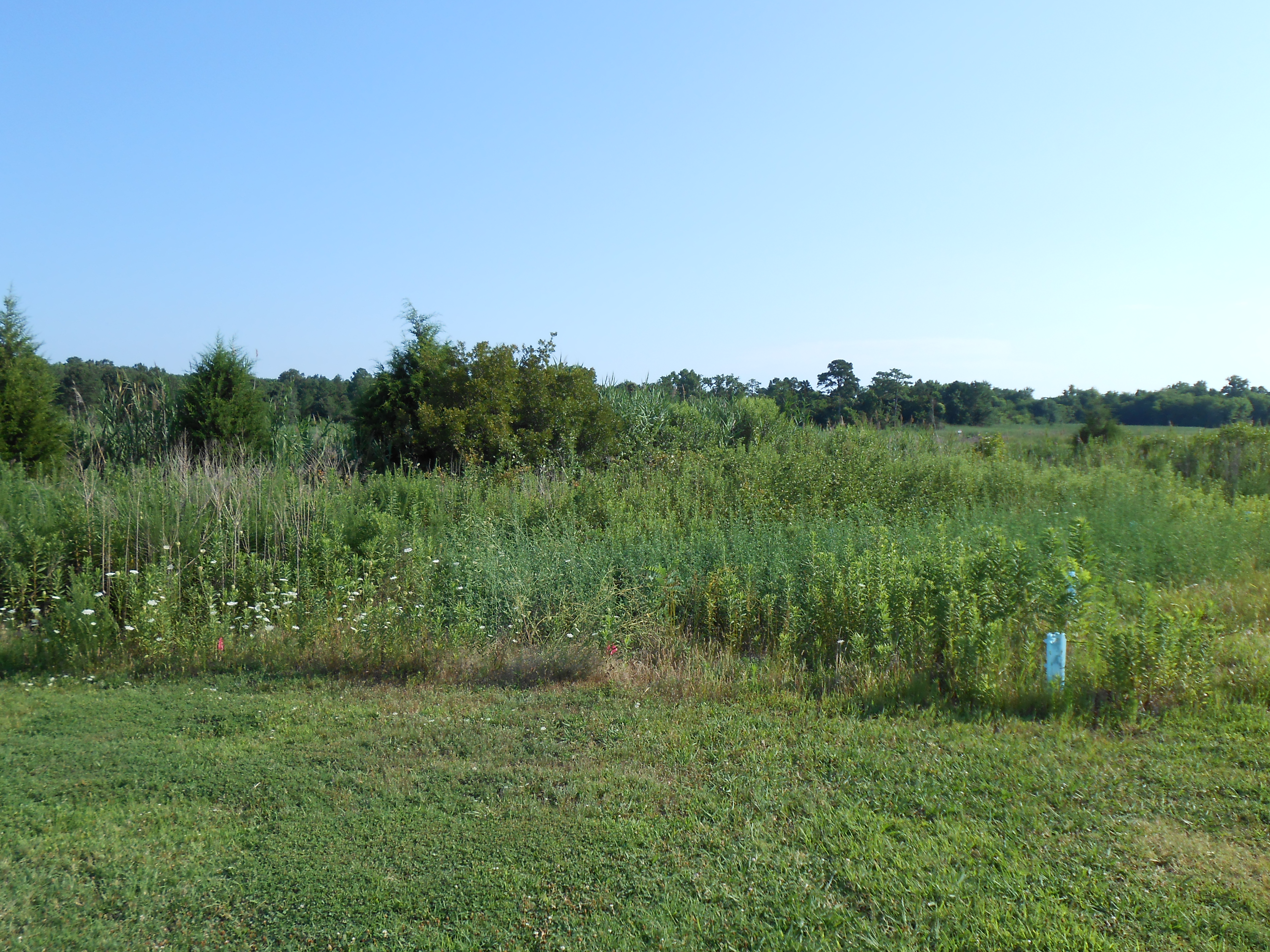
Picture of a riparian buffer after three months of growth.
- LaRC has installed 5 tree box filters. These systems were manufactured by Filterra and are capable of filtering stormwater pollutants. Filterra is similar to bioretention in its function and application but has been optimized for high volume/flow treatment and high pollutant removal. Its small footprint allows it to be used on highly developed sites such as landscaped areas, parking lots, and streetscapes. We installed these as retrofits to treat runoff from parking and street areas. Additionally, the new Katherine G. Johnson Computational Research Facility (CRF) has two new tree box filters.

Note: This page links to PDF files. Use this link to download Adobe Reader if needed.